
Keyline Design
Keyline design is a holistic landscape management system that uses detailed topographic analysis and precise contour mapping to strategically manage water and build soil fertility across an entire property. It employs specific keylines, identified by contour mapping, as pathways for subsoiling and water distribution, thereby accelerating the natural processes of soil building and landscape regeneration at scale, aiming to make every part of the farm more productive.
Read More: Complete Description
Keyline design is a comprehensive, whole-farm landscape planning method developed by P.A. Yeomans in the mid-20th century that harnesses natural topography to optimize water management and soil health. Unlike localized water harvesting techniques, Keyline is a systemic approach that analyzes the entire property's contours to identify 'keylines'—specific topographic points that dictate water flow and soil distribution. These keylines become the basis for designing a network of cultivation and water diversion contours that effectively move water across a landscape to prevent erosion, retain moisture, and build soil fertility from the highest points to the lowest.
The core principle of Keyline design is to balance the land's capacity to receive and absorb water with the amount of water available. By understanding how water naturally flows downhill, Yeomans devised a system to arrest this flow conventionally and redistribute it effectively. This involves creating broad-based contours and specific structures—often employing unique implements like the Yeomans plow (a specialized subsoiler) and precisely designed dams or swales—that guide water from higher rainfall areas or ephemeral streams to drier sections of the farm, maximizing its utility. The design is so integral that it considers the entire property as a single hydrological unit.
Keyline design directly supports several regenerative agriculture principles by creating conditions that allow natural processes to flourish. It primarily supports Minimize Soil Disturbance by employing methods like subsoiling along keylines to break up compacted layers without excessive inversion, creating channels for water and root penetration. It enhances Maintain Living Roots by ensuring that every part of the landscape, including previously unproductive or erosive areas, can support perennial vegetation through improved water availability. The practice inherently promotes Keep Soil Covered by directing water to areas where it can support vigorous plant growth, reducing fallow periods and bare ground.
By enhancing water infiltration and distribution, Keyline design significantly bolsters Maximize Crop Diversity. It transforms challenging topography—steep slopes, dry ridges, or waterlogged hollows—into productive landscapes capable of supporting a wider array of beneficial plants, including trees, shrubs, and diverse forage species. This enhanced water management is also crucial for improved Integrate Livestock, as it ensures consistent pasture growth across the farm, thereby supporting more robust grazing plans and greater animal performance. The system aims to make the entire farm more resilient to drought and variable rainfall.
A common misconception is that Keyline design is simply the construction of dams or swales. While these structures are part of the system, Keyline is fundamentally different from Permaculture's approach to swales. Keyline's methodology is based on rigorous topographic analysis and precise calculations of keylines, which are not necessarily on contour. The aim is to achieve broad-scale water distribution and soil building across the entire landscape, not just localized water harvesting. Yeomans himself was critical of simple contour swales at scale, viewing them as potentially engineering errors that could concentrate water inappropriately if not derived from a holistic topographic survey and keyline principle.
The implementation of Keyline design requires a deep understanding of topography, soil science, and hydrology. It begins with a detailed survey of the land's contours to identify the "point of balance," a critical topographic feature that helps determine the optimal placement of structures and cultivation lines. The system then maps out a network of precisely angled contours and broad-based banks or ploughed lines that follow the "keyline" principle. This principle uses specific points on the land’s contour to achieve a slow, even spread of water across the landscape. The Yeomans plow, specifically designed to fracture compacted subsoils without inversion, is often used along these keylines to prepare the soil for water infiltration and root penetration.
Keyline design's emphasis on long-term landscape health and productivity makes it a powerful tool for regenerative agriculture, particularly for farms facing water scarcity, erosion, or low soil fertility. Its success lies in its ability to engineer natural processes at a landscape scale, transforming arid or degraded land into productive ecosystems capable of sustaining agriculture for generations. By strategically managing water, the system unlocks the land's potential, making previously unproductive areas fertile and improving the overall resilience and economic viability of the farm.
The philosophy behind Keyline design is one of working with, rather than against, natural forces. It recognizes that water is the primary limiting factor in many agricultural systems and that its effective management is key to unlocking soil potential. By creating a series of broad-based terraces or cultivated lines that follow specific topographic relationships, water is slowed, spread, and absorbed, feeding perennials and increasing soil organic matter. This approach inherently supports ecological regeneration by creating conditions for plant life to thrive, support soil biology, and build productive topsoil over time, making it a foundational practice for transforming degraded land into resilient and fertile agroecosystems.
As a foundational regenerative practice, Keyline design lays the groundwork for other regenerative principles by optimizing the landscape's capacity to support life. Its systematic approach to water management is integral to building soil health, enhancing biodiversity, and enabling diverse cropping and grazing systems that are hallmarks of regenerative agriculture. The principles it directly supports are: 1. Minimize Soil Disturbance: While subsoiling is a form of disturbance, it is a one-time intervention to break severe compaction, enabling biological processes to establish and function. The design prioritizes methods that, once implemented, minimize ongoing disturbance. 2. Maximize Crop Diversity: By making more land productively cultivable through water management, Keyline opens opportunities for greater species diversity in pastures, cover crops, and potential agroforestry systems. 3. Keep Soil Covered: The system's focus on distributing water to support vegetation directly leads to increased periods of soil cover year-round. 4. Maintain Living Roots: Enhanced water availability allows for longer growing seasons and the establishment of perennial species, ensuring living roots are in the soil for greater portions of the year. 5. Integrate Livestock: Reliable pasture growth across the farm, facilitated by Keyline water management, underpins successful integration of livestock through improved grazing potential and land restoration.
Sources behind this view
Sources behind this view
 Videos & Podcasts
-
Details PA Yeomans' Keyline plan for water management and soil building in Australia, involving contour mapping and water redistribution to enhance fertility and pasture production. Includes informati

-
Keyline design, developed by P.A. Yeomans in Australia, is a holistic land planning approach using topography to manage water. It creates symmetrical, parallel rows slightly off-contour to move water
-
Keyline design is presented as a superior method for water management and landscape design over swales, focusing on evenly distributing water via cultivation patterns that fall from valleys to ridges

-
Keyline design, using swales and strategic water spreading, optimizes landscape hydrology for farms, transforming barren areas into grasslands and food forests, as seen in projects in Saudi Arabia and

 Community
-
The 'Scale of Permanence' guides permaculture implementation: Climate, Landshaping, Water (swales/berms), Roads, Trees, Buildings, Subdivisions, and Soils. Prioritizing water and land shaping is cruci
Read more (opens in new window) permies.com -
Eric Koperek advises focusing on contour lines and 'boots on the ground' observation for Keyline watershed management. Recommends dams for pasture irrigation, tanks for aquifer recharge, and trenches
Read more (opens in new window) permies.com -
Practical Keyline implementation: select key point, find keyline with 1% grade towards ridges, place parallel swales. Focus on moving water to ridges for even soil moisture and fertility, using dams f
Read more (opens in new window) permies.com -
Keyline systems use a keyline plow to subsoil land every 3 feet, reversing compaction, accelerating topsoil formation, and acting as a sponge to reduce irrigation needs. This method can improve soil w
Read more (opens in new window) permies.com
 Research
-
Modelling the Effect of Keyline Practice on Soil Erosion Control (opens in new window)
This study found: Keylining farming technique, modeled using GIS, reduced soil erosion and improved water infiltration in two small watersheds, offering planning support for farmers.
-
Water For Every Farm: A Practical Irrigation Plan for Every Australian Property (opens in new window)
This study found: Classic text on Keyline Design by P. A. Yeomans, offering systematic approaches to water management for Australian farms to boost productivity and soil health.
 From the Web
-
Explains Keyline design principles for farm water management, focusing on pattern cultivation in valleys and ridges to redirect sheet flow towards higher ground, enhancing soil moisture and drought re
-
Keyline, a farm planning system by P.A. Yeomans and integrated into Regrarians, prioritizes water control for landscape design and soil health, encouraging a combination of methods like rotational gra
-
Workshop on Keyline Design and Yeomans' plow in Waco, Texas (Sept 28-30, 2017) teaches whole-farm planning for soil health, water harvesting, and drought resilience using techniques like Keyline Patte
-
Keyline design uses landscape features to 'slow, sink, and spread' water, identifying keypoints and keylines to plan water collection in dams or ponds, thereby enhancing forage growth and farm resilie
Key Points
What It Is
- Whole-farm topographic water management system
- Uses keylines for strategic water & soil distribution
- Employs specific plowing & earthworks (e.g., Yeomans plow)
- Aims to make every landscape zone productive
How This Differs
- Whole-farm landscape system, not a single earthwork
- Topographic analysis distributes water across the property
- Specific implements along calculated keylines
- Accelerates soil building at landscape scale
Why Do It
- Optimizes water use, reduces drought risk
- Prevents soil erosion, builds soil fertility
- Transforms challenging topography into productive land
- Enhances all five regenerative principles systemically
Know the Debate
- Productivity timeline varies: early pasture response to 5-10 years for soil build
- Mechanism: Hydrology & biology work together; survey precision is key
- Survey needs adapt to farm complexity, scale, and farmer skill
- Keyline foundation enables other regenerative practices
Benefits - Financial
- Increases forage yields by 30–60% annually after 5 years
- Reduces annual irrigation input costs by 20–50% per acre
- Increases raw land value by 200–400% through landscape resilience
Benefits - System
- Erosion reduction: 70-90% decrease
- Soil organic matter increase: 0.5-1.5% over 5-10 years
- Water infiltration: Doubles or triples capacity
- Supports Principles 2, 3, 4, 5 directly
Risks - Financial
- Initial design and earthworks range from $31–$4,345 per acre ($77–$10,737 per hectare)
- Remediation for poor design costs $5,000–$15,000 per damaged location
Risks - System
- Requires precise topographic survey & design
- Misapplication can cause localized erosion/waterlogging
- Relies on understanding hydrology, not just contours
- Not individual swales; misunderstanding of scale is failure
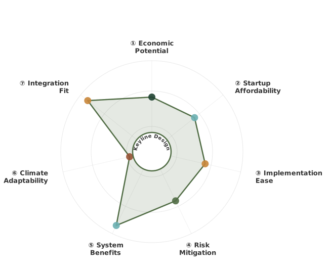
How These Traits Are Calculated
Trait dimensions are ordered clockwise starting from the top of the chart (12 o'clock position):
1. Economic Potential
Financial returns, annual value, and break-even timeline
WHAT: Evaluates financial viability by combining net annual value ($/ha from savings, income, and amortized harvests) with break-even timeline showing when practices pay for themselves.
WHY: Farmers need clear ROI understanding before committing resources. Fast payback (≤3 years) with strong returns (≥$300/ha) enables confident adoption, while long timelines (>10 years) restrict adoption to well-funded operations willing to wait for returns.
HOW: Calculated from net annual value in $/ha and break-even years. Exceptional (≥2.6): fast ROI ≤3 years + high value ≥$300/ha. Typical (1.8-2.5): moderate returns or longer timelines. Limited (<1.8): marginal economics or very long payback >10 years.
2. Startup Affordability
Initial investment costs and financial barrier to entry
WHAT: Measures financial barrier to entry through startup costs for equipment, infrastructure, consulting, and materials. Inverted scoring: lower costs = higher scores = more accessible adoption.
WHY: Affordability determines who can adopt. Low-cost practices (<$250/ha) enable widespread adoption across diverse scales, while high costs (>$2,500/ha) limit adoption to well-capitalized operations, creating barriers that slow regenerative transition.
HOW: Calculated from initial investment parsed from practice content. Inverted scoring: Exceptional (≥2.6): minimal investment <$250/ha. Typical (1.8-2.5): moderate costs $250-2,500/ha. Limited (<1.8): high barrier >$2,500/ha.
3. Implementation Ease
Learning curve and specialized knowledge required
WHAT: Measures how much learning, planning, and specialized knowledge a practice requires. Simpler practices with fewer steps score higher, while complex practices requiring extensive training or specialized resources score lower.
WHY: Complex practices create adoption barriers even when economically viable. Straightforward practices enable faster adoption and broader participation, while those requiring extensive training, timing precision, or specialized equipment limit who can succeed.
HOW: Evaluated by measuring documentation length and identifying complexity markers like location-specific requirements, seasonal timing windows, specialized skills, and dedicated equipment needs. Exceptional (≥2.6): straightforward practices with minimal prerequisites. Typical (1.8-2.5): moderate learning curve with some specialized needs. Limited (<1.8): steep learning curve requiring significant training or resources.
4. Risk Mitigation
Identified financial and ecological risk assessment
WHAT: Evaluates documented risks across financial (investment loss, market volatility) and ecological (crop failure, pest outbreaks) domains. Inverted scoring: fewer risks = higher scores.
WHY: Understanding risk exposure helps farmers make informed decisions. Low-risk practices allow confident implementation, while high-risk practices require careful planning and contingency resources. Risk transparency prevents costly failures.
HOW: Calculated from identified risks in practice content. Inverted scoring: Exceptional (≥2.6): ≤2 risks with manageable severity. Typical (1.8-2.5): 3-5 moderate risks. Limited (<1.8): 6+ risks or severe exposure.
5. System Benefits
How many ways the practice improves your land simultaneously
WHAT: Measures how many aspects of land health improve at once—carbon storage, soil quality, erosion control, water absorption, and biodiversity. Practices that improve multiple areas simultaneously create compounding benefits where each improvement reinforces the others.
WHY: The best practices solve multiple problems at once. For example, addressing erosion simultaneously builds carbon and improves water infiltration, creating a resilient system with positive feedback loops. Single-benefit approaches miss these compound transformation opportunities.
HOW: Evaluated across five key outcomes: carbon sequestration, soil organic matter increase, erosion reduction, water infiltration improvement, and biodiversity enhancement. Exceptional (≥2.6): high carbon storage (>8 t/ha/yr), improvements across 4-5 areas, transformative outcomes. Typical (1.8-2.5): moderate carbon (3-8 t/ha/yr), improvements across 2-3 areas. Limited (<1.8): modest impact (<3 t/ha/yr), single-area focus only.
6. Climate Adaptability
Geographic applicability across Köppen climate zones
WHAT: Evaluates geographic applicability by assessing how many Köppen climate zones successfully support a practice and what adaptation requirements are needed. Measures breadth of climates where farmers can implement with minimal to moderate modifications.
WHY: Universal practices working across diverse climates enable more farmers to adopt regenerative approaches. Practices limited to single climate types (only Mediterranean, only tropical) restrict adoption and slow global transition. Adaptability determines whether a practice serves niche regions or offers broad transformation.
HOW: LLM evaluation of regional success stories, Köppen zone coverage, and adaptation needs. Exceptional (≥2.6): 5+ zones or 4+ climate types, 3+ continents, minimal adaptation. Typical (1.8-2.5): 3-4 zones or 2-3 types, 2 continents, moderate adaptation. Limited (<1.8): 1-2 zones, single region, significant adaptation or highly specialized.
7. Integration Fit
How well this practice combines with others you're doing
WHAT: Measures how well a practice combines with other regenerative practices you might be doing. Some practices work as building blocks that make many other practices easier or more effective, while others work best on their own.
WHY: Practices that combine well with many others create more value on your farm. For example, cover cropping enables no-till, improves grazing, supports crop diversity, and helps water management—making all of them work better together. This helps you build a coherent system rather than juggling disconnected practices.
HOW: Evaluated by identifying which practices combine well and how strong those combinations are. 'Ideally Suited' means strong combinations where practices reinforce each other (practice A makes B easier, while B makes A more effective). 'Adequate' means complementary benefits that work well together. Exceptional (≥2.6): combines well with 6+ practices, serves as a building block. Typical (1.8-2.5): combines with 3-5 practices. Limited (<1.8): 1-2 practices or works best alone.
Going Deeper
1
WHY - The Benefits
Keyline design transforms a farm's water dynamics, unlocking its full productive potential by strategically managing rainfall and runoff. This systematic approach to landscape design offers profound benefits to soil health, economic viability, and the overall ecological...
Keyline design transforms a farm's water dynamics, unlocking its full productive potential by strategically managing rainfall and runoff. This systematic approach to landscape design offers profound benefits to soil health, economic viability, and the overall ecological functioning of the land.
WHY - The Benefits
Keyline design transforms a farm's water dynamics, unlocking its full productive potential by strategically managing rainfall and runoff. This systematic approach to landscape design offers profound benefits to soil health, economic viability, and the overall ecological...
Keyline design transforms a farm's water dynamics, unlocking its full productive potential by strategically managing rainfall and runoff. This systematic approach to landscape design offers profound benefits to soil health, economic viability, and the overall ecological functioning of the land.
Soil Health Benefits
Keyline design's primary impact is on soil health through improved water management. By directing water to areas that are typically dry or erode easily, it ensures consistent moisture availability for plant growth. This leads to increased root penetration, as plants can access water deeper in the soil profile. The sustained presence of living roots, a core regenerative principle, encourages the development of soil structure through root exudates and microbial activity.
As water is slowed and absorbed rather than running off, soil erosion is dramatically reduced. This prevents the loss of valuable topsoil and organic matter. The increased water infiltration leads to higher soil moisture content, fostering a more active soil biology. Earthworm populations and beneficial microbial communities thrive in these conditions, contributing to nutrient cycling, organic matter decomposition, and the formation of stable soil aggregates. The resulting soil gains 0.5-1.5% organic matter over 5-10 years in many regions, transforming depleted soils into fertile, resilient land.
Economic Benefits
The economic returns from Keyline design are substantial and accrue over the medium to long term. Farms that implement Keyline often see significant increases in the productivity of their pastures, by 30-60% or more, allowing for higher stocking rates or improved animal performance. This enhanced pasture growth translates directly into increased livestock revenue.
For agricultural systems reliant on irrigation, Keyline can significantly reduce water usage, leading to 20-50% savings on water costs and energy for pumping. In semi-arid or drought-prone regions, the increased water retention capacity of the soil can mean the difference between crop failure and a successful harvest, providing a critical economic buffer against variable weather.
Furthermore, land successfully managed with Keyline design—especially when integrated with perennial vegetation—appreciates significantly in value. The transformation of previously unproductive or degraded land into fertile, water-secure, and ecologically sound agricultural assets can increase property value by 2 to 5 times over a decade, depending on the initial state of the land and local real estate markets. This appreciation represents a substantial long-term capital gain.
Regenerative Systems Fit
Keyline design is a foundational practice in regenerative agriculture because it systematically enhances the land's capacity to support multiple ecological functions, thereby enabling other regenerative principles to flourish.
Principle 1 (Minimize Soil Disturbance): While the implementation of Keyline earthworks, such as broad-based banks or plowing on keylines, involves some degree of soil movement, it is designed for long-term benefit and often involves subsoiling rather than inversion tillage. Once established, the system promotes methods that minimize further disturbance, with water management supporting perennial cover and reduced need for annual soil preparation. The goal is to break down existing compaction, allowing biological activity to take over soil structure maintenance.
Principle 2 (Maximize Crop Diversity): By making more areas of the farm, including slopes and dryland zones, reliably productive, Keyline design opens up possibilities for increased crop diversity. Watered areas can support a wider range of forage species, cover crops, or even agroforestry components. This increased plant diversity creates more varied habitats and food sources for beneficial insects, soil microbes, and wildlife, improving overall farm ecosystem health.
Principle 3 (Keep Soil Covered): The primary objective of Keyline is to distribute water to support vigorous plant growth across the landscape. This inherently means more land is covered by living plants for longer periods. The improved water retention also allows for denser ground cover and mulch formation, preventing bare soil and its associated risks of erosion and degradation, especially on marginal lands.
Principle 4 (Maintain Living Roots): Enhanced water availability from Keyline management directly supports the establishment and maintenance of perennial vegetation. This ensures that living roots are in the soil for more of the year, providing continuous carbon inputs to soil biology, maintaining soil structure, and supporting nutrient cycling. The system is well-suited for pastures, silvopasture, and perennial cropping systems.
Principle 5 (Integrate Livestock): Keyline design creates a more resilient and productive forage base for livestock. Consistent pasture growth across the entire farm, even in previously marginal areas, allows for more effective rotational grazing strategies. This improved pasture management enhances livestock performance, improves manure distribution for soil fertility, and supports the integration of animals as a key component of the regenerative system.
Keyline design can be seen as an 'enabler' for other regenerative practices. Its ability to transform the hydrological landscape makes it easier to implement practices like no-till farming (by reducing compaction), cover cropping (by providing reliable moisture), and silvopasture (by making wooded slopes or dry areas more viable for integration). It provides the fundamental landscape infrastructure that allows these other practices to reach their full regenerative potential.
Sources behind this view
Videos & Podcasts
-
Details PA Yeomans' Keyline plan for water management and soil building in Australia, involving contour mapping and water redistribution to enhance fertility and pasture production. Includes informati
-
Charlie Furlotte explains Keyline design at Carisbrooke, using diversion banks to channel hill runoff to dams and irrigate plains, transforming scalded clay pans into productive pasture through water
-
Keyline design, developed by P.A. Yeomans in Australia, is a holistic land planning approach using topography to manage water. It creates symmetrical, parallel rows slightly off-contour to move water
-
Explains P.A. Yeomans' Keyline Plan, a land management system dividing landscapes into catchment (forest), retention (water harvesting), irrigation (cropland), and reconstitution (wetlands) zones to h

Community
-
The 'Scale of Permanence' guides permaculture implementation: Climate, Landshaping, Water (swales/berms), Roads, Trees, Buildings, Subdivisions, and Soils. Prioritizing water and land shaping is cruci
Read more (opens in new window) permies.com -
Eric Koperek advises focusing on contour lines and 'boots on the ground' observation for Keyline watershed management. Recommends dams for pasture irrigation, tanks for aquifer recharge, and trenches
Read more (opens in new window) permies.com -
Keyline systems use a keyline plow to subsoil land every 3 feet, reversing compaction, accelerating topsoil formation, and acting as a sponge to reduce irrigation needs. This method can improve soil w
Read more (opens in new window) permies.com -
Practical Keyline implementation: select key point, find keyline with 1% grade towards ridges, place parallel swales. Focus on moving water to ridges for even soil moisture and fertility, using dams f
Read more (opens in new window) permies.com
Research
-
Modelling the Effect of Keyline Practice on Soil Erosion Control (opens in new window)
This study found: Keylining farming technique, modeled using GIS, reduced soil erosion and improved water infiltration in two small watersheds, offering planning support for farmers.
-
Water For Every Farm: A Practical Irrigation Plan for Every Australian Property (opens in new window)
This study found: Classic text on Keyline Design by P. A. Yeomans, offering systematic approaches to water management for Australian farms to boost productivity and soil health.
From the Web
-
Explains Keyline design principles for farm water management, focusing on pattern cultivation in valleys and ridges to redirect sheet flow towards higher ground, enhancing soil moisture and drought re
-
Keyline, a farm planning system by P.A. Yeomans and integrated into Regrarians, prioritizes water control for landscape design and soil health, encouraging a combination of methods like rotational gra
-
Workshop on Keyline Design and Yeomans' plow in Waco, Texas (Sept 28-30, 2017) teaches whole-farm planning for soil health, water harvesting, and drought resilience using techniques like Keyline Patte
-
Keyline design uses landscape features to 'slow, sink, and spread' water, identifying keypoints and keylines to plan water collection in dams or ponds, thereby enhancing forage growth and farm resilie
2
WHERE - Regional Considerations
Keyline design's effectiveness is amplified by its adaptability across diverse climatic and topographic conditions, though specific implementation details must be tailored to local environmental factors. It is particularly valuable in regions with variable rainfall, arid...
Keyline design's effectiveness is amplified by its adaptability across diverse climatic and topographic conditions, though specific implementation details must be tailored to local environmental factors. It is particularly valuable in regions with variable rainfall, arid or semi-arid climates, and landscapes prone to erosion.
WHERE - Regional Considerations
Keyline design's effectiveness is amplified by its adaptability across diverse climatic and topographic conditions, though specific implementation details must be tailored to local environmental factors. It is particularly valuable in regions with variable rainfall, arid...
Keyline design's effectiveness is amplified by its adaptability across diverse climatic and topographic conditions, though specific implementation details must be tailored to local environmental factors. It is particularly valuable in regions with variable rainfall, arid or semi-arid climates, and landscapes prone to erosion.
Click Here to Look up your Region if you don't already know it
Arid and Semi-Arid Regions
Representative Locations: Western USA, North Africa, Central Asia, Interior Australia, parts of the Middle East, Southern Africa. Climate Context: Low annual rainfall (<40 cm or 15 inches), high evaporation rates, often short and unpredictable growing seasons, wide diurnal temperature fluctuations. Köppen BSh/BSk classification. Keyline Application: Critical for maximizing every drop of rainfall. Designs focus on contour plowing and keyline cultivation to spread water from higher rainfall zones (e.g., ridges, areas with natural runoff) to lower zones or flatter areas suitable for planting. Structures emphasize water retention and infiltration. Choice of perennial species becomes paramount, focusing on drought-tolerant grasses, shrubs, and trees capable of surviving with minimal supplemental water once established. Subsoiling is vital to break existing compacted layers that severely limit infiltration.
Mediterranean Regions
Representative Locations: California, Mediterranean basin (Spain, Italy, Greece), central Chile, southwestern Australia, Western Cape South Africa. Climate Context: Hot, dry summers and mild, wet winters. Highly seasonal rainfall (40-90 cm or 15-35 inches annually), with potential for intense downpours during wet season. Köppen Csa/Csb classification. Keyline Application: Effective for managing intense winter rains and mitigating summer drought. Designs focus on capturing winter precipitation to recharge soil moisture for summer growth. Broad-based banks and contour cultivation slow runoff during intense storms, preventing erosion on hillsides. Keyline planning can identify optimal locations for water storage or subsurface moisture enhancement for perennial crops and pastures. Species selection emphasizes drought-tolerant or summer-dormant forages, nut trees, and olive groves.
Humid Temperate Regions
Representative Locations: Southeastern United States, northern Europe (UK, Germany, Poland), eastern China, Japan, New Zealand. Climate Context: Moderate to high annual precipitation (75-150 cm or 30-60 inches) distributed relatively evenly, with warm to hot summers and cool to cold winters. USDA Zones 6-8, Köppen Cfb/Cfa. Keyline Application: While water scarcity is less of a concern, Keyline is still valuable for managing excess water, preventing erosion, and improving soil structure. Designs can focus on draining waterlogged areas, spreading excess moisture to prevent runoff during heavy rain events, and improving infiltration on heavy clay soils prone to compaction. Keyline contour cultivation can enhance pasture productivity, support woodlot health, and enable more diverse crop rotations by improving soil drainage.
Tropical Regions
Representative Locations: Central America, Southeast Asia, East Africa, Northern Australia, Northern South America. Climate Context: High temperatures year-round with distinct wet and dry seasons or consistent high rainfall. Köppen Af/Am/Aw. Keyline Application: Crucial for managing intense seasonal rainfall and preventing severe erosion, especially on steep terrain. Keyline design focuses on broad-based banks and plowing to slow and spread downpours, minimizing soil loss and maximizing water infiltration to support sustained growth during the dry season. It's highly applicable in agroforestry systems, pasture development, and perennial crop cultivation like coffee or cacao, ensuring water availability and fertility are optimized throughout the year. Subsoiling can be particularly beneficial in areas with lateritic hardpans.
3
HOW - Implementation Process
Implementing Keyline design is a systematic process that begins with detailed land assessment and culminates in a landscape-wide network of water management structures and cultivation patterns. While the specifics vary by topography, climate, and intended land use, the...
Implementing Keyline design is a systematic process that begins with detailed land assessment and culminates in a landscape-wide network of water management structures and cultivation patterns. While the specifics vary by topography, climate, and intended land use, the core phases remain consistent.
HOW - Implementation Process
Implementing Keyline design is a systematic process that begins with detailed land assessment and culminates in a landscape-wide network of water management structures and cultivation patterns. While the specifics vary by topography, climate, and intended land use, the...
Implementing Keyline design is a systematic process that begins with detailed land assessment and culminates in a landscape-wide network of water management structures and cultivation patterns. While the specifics vary by topography, climate, and intended land use, the core phases remain consistent.
Prerequisites: Topographic Survey and Analysis
The absolute first step is a high-quality topographic survey of the entire property. This is not a simple contour map; it requires detailed elevation data to accurately identify key elements of the landscape:
- Ridge lines: Highest points of land.
- Drains/Gullies: Natural watercourses.
- Contour lines: Lines of equal elevation.
- "Point of Balance": A critical topographic feature between the ridge and the main valley or 'frog' (point of sharpest slope change). This point holds the key to accurately determining the Keyline.
- Soil type and condition: Understanding existing soil structure, depth, and permeability across different landscape positions.
Tools: GPS surveying equipment (RTK GPS for high accuracy), drone-based photogrammetry with LiDAR, traditional land surveying tools, or skilled observation combined with detailed maps. The accuracy of the survey directly dictates the effectiveness of the design.
Accuracy Requirement: For successful Keyline design, contour intervals should be at most 1 meter (3 feet) for moderate slopes, and ideally 0.5 meters (1.5 feet) for steeper or more complex terrain. The "point of balance" must be precisely located.
Phase 1: Identifying Keylines and Planning Structures
Once the topography is accurately mapped and analyzed, the "keylines" are identified. A keyline is derived from the contour line that runs through the point of balance. By strategically influencing the flow of water away from the ridge at a specific gradient, it can be directed to spread evenly across the land, either upwards or downwards, making the entire landscape more uniformly moist.
Based on the keyline analysis, the Keyline plan is developed:
- Keyline Cultivation Lines: Broad-based ploughed or cultivated lines that follow the keyline principle, designed to slow and spread water. These are not necessarily on contour; they are at a specific, calculated gradient.
- Dam/Water Storage Locations: Identifying optimal positions for small dams or ponds located on drains to capture runoff from higher areas or from the keyline cultivation. These are often positioned to fill from specific keyline structures.
- Earthworks: Planning broad-based banks, diversion channels, and other earthworks that complement the keyline cultivation, guiding and retaining water. Emphasis is on maximizing soil absorption.
Considerations:
- Land Use: Design must align with intended land use (pasture, crops, orchards, silvopasture).
- Climate: Rainfall patterns, intensity, and drought frequency inform the scale of water management.
- Soil Type: Permeability dictates how much water can be absorbed and how quickly it moves.
Phase 2: Earthworks and Subsoiling (Field Implementation)
This phase involves constructing the planned earthworks and implementing the Keyline cultivation.
- Yeomans Plow (Subsoiler): If severe compaction is present, a Yeomans plow or similar subsoiler is used along the keylines. This fracture the compacted subsoil layer to depths of 30-50 cm (12-20 inches) without inverting the soil. This action opens up channels for water penetration and root growth, essential for breaking the cycle of poor infiltration. The plowing is done at an angle calculated from the keyline, not strictly on contour.
- Broad-Based Banks and Contour Plowing: These are constructed to slow water flow, spread it laterally, and maximize infiltration. They are designed to be stable and not erode themselves. They are angled relative to contour to interact with the keyline flow.
- Dams and Storage: Small, shallow farm dams are strategically placed to capture runoff. They are often designed to be self-filling from the keyline cultivation or nearby drains, acting as reservoirs to provide supplementary water during dry periods.
Equipment: Tractors, specialized subsoilers (Yeomans plow), earthmoving equipment (for larger dams), and graders or specialized plows for constructing broad-based banks.
Labor: This phase can be labor-intensive, especially for smaller-scale operations or when using specific Yeomans-designed implements. Hiring experienced contractors for earthworks is often advisable.
Phase 3: Establishing Vegetation and Ongoing Management
Once earthworks are in place and subsoiling completed, the focus shifts to establishing vegetation that utilizes the improved water availability.
- Pasture Establishment: Seeding diverse, deep-rooted perennial pastures that can capitalize on the increased moisture.
- Tree Planting: Planting fruit trees, timber trees, or windbreaks in keyline-cultivated areas or along contours to further stabilize soil and utilize water.
- Crop Management: If used for annual cropping, careful planning of planting times and crop choice for optimal water use is essential.
Management: Continuous monitoring of water flow patterns, soil moisture levels, and vegetation performance. Fine-tuning structures and cultivation patterns as needed based on observed outcomes. Gradual reduction of any external water inputs as the system regenerates soil, relying more on natural rainfall capture.
International Context: In regions with limited access to specialized Keyline equipment, modified subsoilers or even well-designed broad-based contour plows can be adapted. The principles of topographic analysis and keyline planning remain the same, but implementation might require more ingenuity.
Transition Timeline & Phase-Out Strategy
Keyline design is not typically a transition practice; it is a foundational landscape intervention. It does not usually violate regenerative principles beyond the initial disturbance of earthworks, and aims to immediately enhance principles like soil cover and living roots. However, if it is implemented on land previously subject to practices that depleted soil biology (e.g., heavy tillage, monoculture), the "transition" is the rebuilding of soil biology over several years following the earthworks.
- Years 0-2: Focus on establishing dense, diverse perennial vegetation (pastures, cover crops, trees) that can capitalize on the new water dynamics. Monitor for erosion, adjust earthworks if needed, and begin building soil organic matter.
- Years 3-5: Observe significant improvements in soil moisture retention, pasture productivity, and potentially reduced need for supplemental irrigation. Begin noticing increased earthworm activity and better soil structure.
- Years 5-10: The system matures. Soil fertility and water-holding capacity are demonstrably improved across the property. The need for artificial water management diminishes as the land achieves a more natural, drought-resilient balance. Regenerative principles are fully realized, with minimal ongoing soil disturbance and maximal biological activity.
Sources behind this view
Videos & Podcasts
-
Details PA Yeomans' Keyline plan for water management and soil building in Australia, involving contour mapping and water redistribution to enhance fertility and pasture production. Includes informati
-
Charlie Furlotte explains Keyline design at Carisbrooke, using diversion banks to channel hill runoff to dams and irrigate plains, transforming scalded clay pans into productive pasture through water
-
Keyline design, incorporating swales and berms, is used for water harvesting and management, inspired by Australian permaculture. This enhances drought resilience and maximizes resource use, moving aw

-
Keyline design is presented as a superior method for water management and landscape design over swales, focusing on evenly distributing water via cultivation patterns that fall from valleys to ridges
Community
-
Eric Koperek advises focusing on contour lines and 'boots on the ground' observation for Keyline watershed management. Recommends dams for pasture irrigation, tanks for aquifer recharge, and trenches
Read more (opens in new window) permies.com -
The 'Scale of Permanence' guides permaculture implementation: Climate, Landshaping, Water (swales/berms), Roads, Trees, Buildings, Subdivisions, and Soils. Prioritizing water and land shaping is cruci
Read more (opens in new window) permies.com -
Practical Keyline implementation: select key point, find keyline with 1% grade towards ridges, place parallel swales. Focus on moving water to ridges for even soil moisture and fertility, using dams f
Read more (opens in new window) permies.com -
Keyline systems use a keyline plow to subsoil land every 3 feet, reversing compaction, accelerating topsoil formation, and acting as a sponge to reduce irrigation needs. This method can improve soil w
Read more (opens in new window) permies.com
Research
-
Modelling the Effect of Keyline Practice on Soil Erosion Control (opens in new window)
This study found: Keylining farming technique, modeled using GIS, reduced soil erosion and improved water infiltration in two small watersheds, offering planning support for farmers.
From the Web
-
Explains Keyline design principles for farm water management, focusing on pattern cultivation in valleys and ridges to redirect sheet flow towards higher ground, enhancing soil moisture and drought re
-
Keyline design uses landscape features to 'slow, sink, and spread' water, identifying keypoints and keylines to plan water collection in dams or ponds, thereby enhancing forage growth and farm resilie
4
Know the Debate
Keyline design transforms landscapes by managing water at scale, but outcomes depend heavily on where you are and your management approach. In humi...
Know the Debate
Keyline design transforms landscapes by managing water at scale, but outcomes depend heavily on where you are and your management approach. In humi...
Keyline design transforms landscapes by managing water at scale, but outcomes depend heavily on where you are and your management approach. In humid temperate regions with reliable rainfall and good soil biology, pasture response and soil improvements can appear faster, within 1-2 years for initial gains and 5-10 years for deeper soil health. Arid regions require more patience, with significant soil building taking 5-10 years and emphasizing drought-tolerant species. Initial investment varies from $100-$500/hectare for large-scale plowing to $800-$2,500/hectare for detailed surveys and earthworks on smaller, complex sites. Success hinges on precise topographic analysis for large areas, but adaptive strategies can work on smaller scales, with ongoing labor for vegetation management.
How long until Keyline design shows full productivity?
Early pasture response (1-2 yrs) & moderate soil gain (5-10 yrs)
Institute and academic sources outline visible pasture improvements within 1-2 seasons and substantial soil health gains over 5-10 years. This timeframe is typical for well-managed perennial systems in regions with adequate rainfall, where improved infiltration directly supports plant growth.
Sources behind this view
Sources behind this view
Research
-
Agriculture Insights for Improving the Soil Conservation through Optimizing of Water Storage and Advanced Agricultural Methods (opens in new window)
This study found: Soil damage has worsened over recent decades due to human actions and urbanization. Protecting soil and managing water effectively are key to healthy agriculture. Adding organic matter to soil is vital because it improves soil structure, helps soil hold more water, allows water to soak in better, and protects the soil from being washed away or compacted. Optimizing water use for crops is important, and restoring soil health can help buffer against climate challenges and boost fertility. Water comes from rain, surface sources, and groundwater. Using groundwater for irrigation and exploring methods like solar-powered water storage can help. The study suggests that vertical flow constructed wetlands are more effective than horizontal ones for managing water in farmlands.
From the Web
-
Keyline design accelerates topsoil formation by improving conditions for soil life, converting subsoil into topsoil over 2-3 years by providing air, water, and food.
-
Permaculture design prioritizes water conservation by slowing, spreading, and sinking precipitation. Key strategies include increasing soil organic matter, using mulches and groundcovers, and implementing features like swales and Keyline design to manage water flow and enhance soil moisture retention.
Dramatic transformation (2-3 yrs) & rapid soil build (inches in 3 yrs)
Field practitioners often describe rapid, dramatic transformations, with barren areas becoming productive within 2-3 years and substantial topsoil formation claimed in similar timeframes. These claims often emphasize immediate visual improvements and drought resilience achieved through effective water spreading and biological activity.
Sources behind this view
Sources behind this view
Videos & Podcasts
-
Keyline design, developed by P.A. Yeomans and taught by Darren Doherty, utilizes 'keypoints' in the landscape to optimize water harvesting and hydrology, offering a more effective and predictable system than traditional contouring.
-
Keyline design, developed by P.A. Yeomans in Australia, is a holistic land planning approach using topography to manage water. It creates symmetrical, parallel rows slightly off-contour to move water from valleys to ridges, optimizing infiltration and minimizing erosion, especially beneficial for mechanized farming.
-
Keyline design uses topography to improve soil and water vitality. Subsoilers, like the Keyline plow, relieve soil compaction by loosening soil, creating channels for water infiltration and root growth, addressing a major farm limiting factor.
Making Sense of the Differences
The timeline for realizing full productivity from Keyline design varies significantly based on initial land condition, climate, and management. Humid regions may see rapid pasture response (1-2 yrs) and soil improvements (5-10 yrs). Arid or degraded landscapes take longer (5-10+ yrs) for deep soil building. Patience, consistent management, and species selection appropriate to the climate are critical for achieving desired outcomes.
How does Keyline design primarily improve soil and water health?
Hydrologic redistribution & soil fracturing
Sources emphasizing Keyline's topographic analysis and subsoiling highlight its ability to fracture compacted subsoils and strategically redistribute water, improving infiltration and root penetration. This mechanical intervention is crucial for breaking compaction and enhancing soil structure.
Sources behind this view
Sources behind this view
Videos & Podcasts
-
Keyline design uses topography to improve soil and water vitality. Subsoilers, like the Keyline plow, relieve soil compaction by loosening soil, creating channels for water infiltration and root growth, addressing a major farm limiting factor.
Research
-
Modelling the Effect of Keyline Practice on Soil Erosion Control (opens in new window)
This study found: This study used computer mapping (GIS) and detailed terrain data to compare two small watersheds before and after applying a farming technique called 'keylining'. Keylining involves shaping the land along specific contours to manage water. The results showed that keylining positively impacted soil by reducing erosion and improving water infiltration, meaning more water soaked into the ground. The researchers suggest that these computer models can help farmers and advisors plan effective keyline designs to better manage soil and water resources.
From the Web
-
Explains Keyline design principles for farm water management, focusing on pattern cultivation in valleys and ridges to redirect sheet flow towards higher ground, enhancing soil moisture and drought resistance. Emphasizes the need for landscape-specific adjustments beyond Yeomans' original geometry.
-
For steep primary valleys in complex landscapes, Yeomans's brief recommendation for a herringbone pattern using tractor-attached implements is highlighted as a revolutionary technique for water management.
Biological response to improved water & organic matter build
Field practitioners and some academic texts focus on the subsequent biological improvements, asserting that Keyline's enhanced water availability and organic matter distribution stimulate soil life, accelerate topsoil formation, and create self-maintaining productive ecosystems.
Sources behind this view
Sources behind this view
Videos & Podcasts
-
Keyline design is presented as a superior method for water management and landscape design over swales, focusing on evenly distributing water via cultivation patterns that fall from valleys to ridges to improve infiltration and break up soil compaction.
-
Explains the development of keyline design, identifying the keyline as a perfect guideline found where valley slope changes from flat to steep, enabling effective water management and erosion control through parallel plowing.

From the Web
-
Keyline design accelerates topsoil formation by improving conditions for soil life, converting subsoil into topsoil over 2-3 years by providing air, water, and food.
-
Permaculture design prioritizes water conservation by slowing, spreading, and sinking precipitation. Key strategies include increasing soil organic matter, using mulches and groundcovers, and implementing features like swales and Keyline design to manage water flow and enhance soil moisture retention.
Making Sense of the Differences
Keyline design's benefits stem from a synergy between mechanical and biological processes. Initial earthworks and subsoiling improve water infiltration and distribution, breaking compaction. This engineered hydrology then supports vigorous plant growth and soil biology, which actively build soil structure and fertility over time. The observed outcomes result from this integrated approach, where improved water management creates conditions for ecological regeneration.
How critical is precise topographic survey for Keyline success?
High precision survey essential for optimal results
Academic and institute sources emphasize the criticality of high-accuracy topographic surveys and precise identification of keylines for correct water distribution and to prevent negative outcomes like erosion or waterlogging.
Sources behind this view
Sources behind this view
Research
-
Modelling the Effect of Keyline Practice on Soil Erosion Control (opens in new window)
This study found: This study used computer mapping (GIS) and detailed terrain data to compare two small watersheds before and after applying a farming technique called 'keylining'. Keylining involves shaping the land along specific contours to manage water. The results showed that keylining positively impacted soil by reducing erosion and improving water infiltration, meaning more water soaked into the ground. The researchers suggest that these computer models can help farmers and advisors plan effective keyline designs to better manage soil and water resources.
-
Application of Geographic Information System and Automated Guidance System in Optimizing Contour and Terrace Farming (opens in new window)
This study found: This study shows how to use mapping software (GIS) and auto-steer systems with GPS to make contour and terrace farming more effective, especially on sloped land. Researchers in the Texas High Plains developed ways to improve the guidance lines that auto-steer systems follow. These methods include smoothing out rough lines, combining multiple guidance paths into simpler ones, and creating clearer navigation routes for complex fields. They also show how to create these guidance lines using elevation data from GPS. By combining mapping tools with auto-steer technology, farmers can operate their equipment more precisely, which helps conserve soil and water resources. The key is to adjust the settings based on the specific field and what the farmer needs for easy and effective operation.
From the Web
-
Explains Keyline design principles for farm water management, focusing on pattern cultivation in valleys and ridges to redirect sheet flow towards higher ground, enhancing soil moisture and drought resistance. Emphasizes the need for landscape-specific adjustments beyond Yeomans' original geometry.
-
Workshop on Keyline Design and Yeomans' plow in Waco, Texas (Sept 28-30, 2017) teaches whole-farm planning for soil health, water harvesting, and drought resilience using techniques like Keyline Pattern Cultivation and GIS contour surveys.
Adaptive observation can suffice on simpler terrains
Some field practitioners argue that while precision is ideal, generalized contouring and adaptive observation based on landscape flow can yield significant benefits, especially at smaller scales or in less complex terrains, making absolute precision less of a barrier.
Sources behind this view
Sources behind this view
Videos & Podcasts
-
Keyline design, developed by P.A. Yeomans and taught by Darren Doherty, utilizes 'keypoints' in the landscape to optimize water harvesting and hydrology, offering a more effective and predictable system than traditional contouring.
-
Keyline design is presented as a superior method for water management and landscape design over swales, focusing on evenly distributing water via cultivation patterns that fall from valleys to ridges to improve infiltration and break up soil compaction.
-
Keyline design, developed by P.A. Yeomans in Australia, is a holistic land planning approach using topography to manage water. It creates symmetrical, parallel rows slightly off-contour to move water from valleys to ridges, optimizing infiltration and minimizing erosion, especially beneficial for mechanized farming.
-
Explains keyline design principles, contrasting with contour farming, and defines key landscape features like keypoints, ridges, and valleys using a hand analogy for water management.
Making Sense of the Differences
The debate on survey accuracy highlights a trade-off between theoretical precision and practical adaptation. While high-accuracy surveys are ideal for complex, large-scale Keyline projects to ensure optimal water distribution and mitigate risks, simpler, adaptive, observation-based contouring may still provide benefits on smaller or less complex farms. Farmers should choose their approach based on their land's specific conditions, scale, available resources, and comfort level with risk and adaptation.
5
HOW MUCH - Costs & Investment
Note: Costs shown in USD; multiply by local labor and material cost indices for your region. Labor costs vary significantly internationally. Vegetation establishment costs are separate and depend on land use.
Note: Costs shown in USD; multiply by local labor and material cost indices for your region. Labor costs vary significantly internationally. Vegetation establishment costs are separate and depend on land use.
HOW MUCH - Costs & Investment
Note: Costs shown in USD; multiply by local labor and material cost indices for your region. Labor costs vary significantly internationally. Vegetation establishment costs are separate and depend on land use.
Note: Costs shown in USD; multiply by local labor and material cost indices for your region. Labor costs vary significantly internationally. Vegetation establishment costs are separate and depend on land use.
Note: All costs are based on recent US economic data (2024–2026) and may vary substantially by region based on local labor rates, material costs, and regulatory requirements.
Design and Professional Services
Comprehensive landscape analysis is the foundational cost for any Keyline project. For small scales (under 50 acres (20 ha)), professional topographic mapping and project planning typically range from $208 to $624 per acre ($514–$1,542/ha). Mid-scale operations (50–500 acres (20–202 ha)) see costs between $416 and $1,248 per acre ($1,028–$3,084/ha). Large-scale operations (500+ acres) benefit from economies of scale, with design and survey costs ranging from $832 to $4,161 per acre ($2,056–$10,282/ha) depending on the complexity of the topography and the depth of the water-management hydrologic plan.
Earthworks and Physical Implementation
The physical movement of soil and implementation of water-distribution infrastructure represents the primary capital expenditure. Small-scale projects focused on minor subsoiling and small-scale water features cost between $125 and $417 per acre ($309–$1,030/ha). Mid-scale operations, which often involve custom hiring heavy machinery, range from $62 to $250 per acre ($153–$618/ha). Large-scale operations optimize this process through serialized implementation, with broad-scale subsoiling and strategic drainage patterns costing between $31 and $125 per acre ($77–$309/ha). These figures assume standard soil types and do not include unforeseen geological obstructions requiring specialized heavy equipment.
Total Initial Investment
When aggregating design and infrastructure, the total capital outlay varies by management intensity. Small-scale projects require an investment range of $333 to $1,042 per acre ($823–$2,575/ha). Mid-scale properties generally see total costs between $104 and $1,511 per acre ($257–$3,734/ha). Large-scale agricultural operations, leveraging massive efficiency in earthworks and streamlined survey methodologies, range from $31 to $4,345 per acre ($77–$10,737/ha), with higher costs correlated to the complexity of dam construction or multi-watershed diversion projects.
Most Spend: Most agricultural operations fall within the middle 60% of these ranges. Small-scale farmers typically spend $505–$758 per acre ($1,248–$1,873/ha). Mid-scale producers typically allocate $295–$632 per acre ($729–$1,562/ha). Large-scale managers typically achieve results with an expenditure of $126–$295 per acre ($311–$729/ha).
Why the Range?: The primary drivers of cost variance are topography and machine access. Flatter, high-visibility landscapes require less intensive surveying and smaller earthmoving footprints, keeping costs at the low end. Conversely, complex, undulating terrain requiring multi-stage water storage engineering, specialized subsoiling equipment, and extensive site-specific vegetation buffers pushes projects to the upper end of the cost spectrum.
6
REWARDS AND RISKS - Economics & Risk Factors
Keyline design offers significant long-term economic rewards by transforming a farm's hydrological potential into productive capacity, but it also carries inherent risks if not planned and implemented correctly.
Keyline design offers significant long-term economic rewards by transforming a farm's hydrological potential into productive capacity, but it also carries inherent risks if not planned and implemented correctly.
REWARDS AND RISKS - Economics & Risk Factors
Keyline design offers significant long-term economic rewards by transforming a farm's hydrological potential into productive capacity, but it also carries inherent risks if not planned and implemented correctly.
Keyline design offers significant long-term economic rewards by transforming a farm's hydrological potential into productive capacity, but it also carries inherent risks if not planned and implemented correctly.
Economic Scenarios In a best-case scenario, Keyline design increases carrying capacity by 50–60%, resulting in a 2x increase in stocking rates. Returns are realized within 7–10 years, and land value frequently appreciates by 300–400% through improved water stability. In a typical scenario, operations see a 30–40% increase in pasture productivity and a 20–30% reduction in irrigation utility costs, with a 200–300% boost in land value after 8–15 years. Conversely, in a worst-case scenario, poorly placed keylines induce localized erosion or waterlogging; this can result in the loss of 100% of the initial investment and a 10–15% decline in total farm asset value due to remedial soil damage.
Market Factors and Mitigation Profitability is heavily dictated by fluctuations in equipment fuel costs and the market price of livestock, which directly affects the time-to-recoupment for high-upfront-cost water systems. Risk mitigation strategies, such as conducting a $500–$2,000 professional diagnostic survey before breaking ground, prevent the most common failure: incorrect keyline placement. By ensuring the "key point" is accurately identified, managers reduce the risk of structural failure—such as dam breaches or gully erosion—which can cost an additional $5,000–$15,000 to remediate on large-acreage systems.
Transition Period Risks While Keyline design is foundational, managers often encounter a 1–3 year "adjustment phase" where soil hydrology is recalibrating. During this period, pasture productivity may remain flat or fluctuate minimally as subsoiling effects take hold. To mitigate this, managers should stagger earthworks across different blocks to ensure 70–80% of the property remains in full production while the intervention settles. Proactive management of temporary fences and grazing rotations during this time prevents soil compaction on recently worked areas, which is vital to protecting the $100–$500 per acre ($247–$1,236/ha) investment in subsoil structural integrity.
Sources behind this view
Videos & Podcasts
-
Details PA Yeomans' Keyline plan for water management and soil building in Australia, involving contour mapping and water redistribution to enhance fertility and pasture production. Includes informati
-
Keyline design, using swales and strategic water spreading, optimizes landscape hydrology for farms, transforming barren areas into grasslands and food forests, as seen in projects in Saudi Arabia and
-
Charlie Furlotte explains Keyline design at Carisbrooke, using diversion banks to channel hill runoff to dams and irrigate plains, transforming scalded clay pans into productive pasture through water
-
Keyline design is presented as a superior method for water management and landscape design over swales, focusing on evenly distributing water via cultivation patterns that fall from valleys to ridges
Community
-
Eric Koperek advises focusing on contour lines and 'boots on the ground' observation for Keyline watershed management. Recommends dams for pasture irrigation, tanks for aquifer recharge, and trenches
Read more (opens in new window) permies.com -
Practical Keyline implementation: select key point, find keyline with 1% grade towards ridges, place parallel swales. Focus on moving water to ridges for even soil moisture and fertility, using dams f
Read more (opens in new window) permies.com -
The 'Scale of Permanence' guides permaculture implementation: Climate, Landshaping, Water (swales/berms), Roads, Trees, Buildings, Subdivisions, and Soils. Prioritizing water and land shaping is cruci
Read more (opens in new window) permies.com -
Keyline systems use a keyline plow to subsoil land every 3 feet, reversing compaction, accelerating topsoil formation, and acting as a sponge to reduce irrigation needs. This method can improve soil w
Read more (opens in new window) permies.com
Research
-
Modelling the Effect of Keyline Practice on Soil Erosion Control (opens in new window)
This study found: Keylining farming technique, modeled using GIS, reduced soil erosion and improved water infiltration in two small watersheds, offering planning support for farmers.
From the Web
-
Explains Keyline design principles for farm water management, focusing on pattern cultivation in valleys and ridges to redirect sheet flow towards higher ground, enhancing soil moisture and drought re
-
Keyline, a farm planning system by P.A. Yeomans and integrated into Regrarians, prioritizes water control for landscape design and soil health, encouraging a combination of methods like rotational gra
-
Keyline design uses landscape features to 'slow, sink, and spread' water, identifying keypoints and keylines to plan water collection in dams or ponds, thereby enhancing forage growth and farm resilie
7
WHO - Labor & Expertise
Successful Keyline design requires a blend of specialized knowledge and practical execution skills, with variations in labor needs depending on the scale of the project and the available resources.
Successful Keyline design requires a blend of specialized knowledge and practical execution skills, with variations in labor needs depending on the scale of the project and the available resources.
WHO - Labor & Expertise
Successful Keyline design requires a blend of specialized knowledge and practical execution skills, with variations in labor needs depending on the scale of the project and the available resources.
Successful Keyline design requires a blend of specialized knowledge and practical execution skills, with variations in labor needs depending on the scale of the project and the available resources.
Expertise Requirements
- Topographic Surveying: This is the most critical expertise. A deep understanding of land surveying techniques, contour mapping, and hydrological principles is essential. The ability to identify the 'point of balance' and calculate precise keyline gradients is paramount. This is often provided by specialized land surveyors, agricultural engineers, or experienced Keyline designers.
- Hydrology and Soil Science: Understanding how water behaves across different soil types, slopes, and under various vegetation covers. This informs species selection, earthwork design, and long-term management.
- Agricultural/Pasture Management: Knowledge of pasture species, their water needs, and grazing management techniques is vital for establishing and maintaining vegetation that capitalizes on Keyline improvements. For cropping, understanding crop water requirements and soil amendments is necessary.
- Earthmoving and Construction: Practical skills in operating heavy machinery for constructing dams, broad-based banks, and possibly using specialized plows are required for the physical implementation of the design.
Labor Needs
- Design Phase: Primarily requires professional surveyors and Keyline designers. This is usually a consultant-based service.
- Earthworks Phase: Can range from DIY (if experienced and with owned equipment) to hiring custom earthmoving contractors. For larger projects, dedicated earthwork crews are typical. This phase is labor-intensive and equipment-heavy.
- Vegetation Establishment: Requires standard agricultural labor for seeding, planting, fencing, and ongoing pasture/crop management.
- Ongoing Maintenance: Periodic checks and minor repairs to earthworks, drains, and vegetation; typically integrated into standard farm maintenance routines.
International Labor Cost Considerations
- High Labor Cost Regions: (e.g., Western Europe, North America, Australia) Hiring custom contractors for earthworks and professional surveyors is common. DIY may be challenging due to equipment costs. Focus is on efficient, skilled execution and long-term planning to maximize return on investment.
- Moderate Labor Cost Regions: (e.g., Eastern Europe, parts of South America) A blend of DIY and hired custom work is feasible. Local contractors may offer more affordable services. Expertise may be less abundant, requiring careful vetting.
- Low Labor Cost Regions: (e.g., parts of Africa, Asia) DIY implementation with community support can be more viable for earthworks, though specialized surveying expertise might still need to be sourced internationally or through advanced training. The emphasis is on labor-intensive construction methods.
Sourcing Expertise
- Keyline Design Consultants: Individuals or firms specializing in Yeomans' Keyline design principles.
- Agricultural Extension Services: Local government or university extension offices may offer advice or connect you with relevant experts.
- Experienced Farmers: Farmers who have successfully implemented Keyline design can offer invaluable practical insights.
- Professional Surveyors: Crucial for the initial topographic analysis.
8
EQUIPMENT - Tools & Infrastructure
Implementing Keyline design requires specialized surveying equipment for the initial planning and specific machinery for earthworks and subsequent vegetation management. Once established, the system often reduces the need for other intensive equipment.
Implementing Keyline design requires specialized surveying equipment for the initial planning and specific machinery for earthworks and subsequent vegetation management. Once established, the system often reduces the need for other intensive equipment.
EQUIPMENT - Tools & Infrastructure
Implementing Keyline design requires specialized surveying equipment for the initial planning and specific machinery for earthworks and subsequent vegetation management. Once established, the system often reduces the need for other intensive equipment.
Implementing Keyline design requires specialized surveying equipment for the initial planning and specific machinery for earthworks and subsequent vegetation management. Once established, the system often reduces the need for other intensive equipment.
Surveying Equipment
- High-Precision GPS Surveying Tools: RTK (Real-Time Kinematic) GPS systems are ideal for achieving centimeter-level accuracy, crucial for identifying keylines and contour points precisely.
- Total Stations: Traditional surveying instruments that, when used with prism poles, can also achieve high accuracy for topographic mapping.
- Drones with LiDAR/Photogrammetry: Increasingly used for rapid, detailed topographic mapping of large areas, generating Digital Elevation Models (DEMs) from which keylines can be derived.
- Traditional Contour Plowing and Measuring Tools: For smaller-scale or less complex terrain, manual methods using A-frames, water levels, and simple plows might suffice, but require more time and skill.
Earthmoving Equipment
- Tractors: A robust tractor (ranging from 50-200+ horsepower depending on scale and terrain) is essential for pulling the specialized plows and any towing for smaller earthmoving equipment.
- Subsoilers / Rippers (Yeomans Plow): This is the most specific Keyline implement. designed to fracture subsoil layers to depths of 30-50 cm (12-20 inches) without inverting the soil. If a true Yeomans plow isn't available, deep-ripping tines or parabolic subsoilers can be adapted.
- Broad-Based Plows / Graders: Specialized plows or graders used to construct broad-based banks and diversion channels that are stable and non-eroding. These are designed to move soil without creating steep sides.
- Earthmoving Machinery: For larger dams and significant earthworks, backhoes, excavators, or even bulldozers may be required. These are typically hired on a custom basis.
- Cultipackers / Rollers: Used to firm the soil surface after seeding cover crops, improving seed-to-soil contact.
Vegetation Management Equipment
- Seed Drills / Planters: No-till drills are ideal for establishing cover crops or pastures immediately after subsoiling or on prepared Keyline cultivation lines, minimizing further soil disturbance.
- Pasture Implements: Mowers, Pasture toppers, or roller-criminers (for cover crop termination) may be used depending on the land use.
- Fencing: Electric fencing is often used for managing livestock in areas that have been improved by Keyline design, allowing for rotational grazing and protecting young vegetation.
- Irrigation Equipment (if applicable): While Keyline aims to reduce reliance on irrigation, some systems may still benefit from supplemental watering, especially during establishment or in extremely arid regions. This could include pumps, pipes, and sprinklers.
Infrastructure
- Water Storage (Dams/Ponds): Strategically located and sized according to water capture potential and farm needs.
- Drainage Ditches/Channels: For directing excess water or managing waterlogging where necessary.
- Roadways/Access Tracks: Keyline design can influence farm layout, potentially requiring planned access routes for machinery and livestock that are integrated with the water management system.
International Sourcing:
- Specialized Keyline implements (like the Yeomans plow) may be difficult to source directly in all regions. Farmers may need to adapt standard subsoilers or engage local fabricators to build custom equipment based on Keyline principles.
- Surveying equipment is globally available, but rental versus purchase decisions depend on frequency of use and local costs.
- Standard earthmoving and agricultural machinery are generally accessible worldwide.
Sources behind this view
Videos & Podcasts
-
Keyline design and plowing improve pasture aeration and water movement by subsoiling without topsoil disturbance, alleviating wet spots and enhancing grass growth. DIY plow construction is also discus

-
Keyline design uses topography to improve soil and water vitality. Subsoilers, like the Keyline plow, relieve soil compaction by loosening soil, creating channels for water infiltration and root growt
-
Keyline design, influenced by P.A. Yeomans, uses topographic mapping and specialized plows (like the Yeomans plow) to manage water movement and break soil compaction, optimizing landscape planning fro

-
Keyline design principles optimize infrastructure placement (roads, animal pens, fencing) for passive water management and efficient farm operations, contrasting with the non-equidistant nature of swa
Community
-
Keyline systems use a keyline plow to subsoil land every 3 feet, reversing compaction, accelerating topsoil formation, and acting as a sponge to reduce irrigation needs. This method can improve soil w
Read more (opens in new window) permies.com
9
COMPATIBLE PRACTICES - Integration Opportunities
Keyline design is a foundational landscape strategy that synergizes exceptionally well with a broad range of regenerative agriculture practices, amplifying their effectiveness and accelerating the transition to a fully functional regenerative system.
Keyline design is a foundational landscape strategy that synergizes exceptionally well with a broad range of regenerative agriculture practices, amplifying their effectiveness and accelerating the transition to a fully functional regenerative system.
COMPATIBLE PRACTICES - Integration Opportunities
Keyline design is a foundational landscape strategy that synergizes exceptionally well with a broad range of regenerative agriculture practices, amplifying their effectiveness and accelerating the transition to a fully functional regenerative system.
Keyline design is a foundational landscape strategy that synergizes exceptionally well with a broad range of regenerative agriculture practices, amplifying their effectiveness and accelerating the transition to a fully functional regenerative system.
No-Till Farming
- Integration: Keyline subsoiling addresses compaction issues that often prohibit successful no-till adoption. By fracturing hardpans, it creates channels for root growth, which then helps maintain soil structure without further tillage.
- Benefit: Keyline improves the soil's capacity to absorb water, making it more resilient to the impacts of no-till while fostering the biological activity that underpins no-till success.
Cover Cropping
- Integration: Improved water availability from Keyline design supports more diverse and vigorous cover crop growth, even on marginal lands. Cover crops contribute organic matter, further enhancing soil structure and biology.
- Benefit: Keyline ensures that the water needed for successful cover crop establishment and growth is available for longer periods, leading to better soil protection and fertility building.
Agroforestry / Silvopasture
- Integration: Keyline design can be used to strategically place trees and shrubs on keylines or carefully planned contours, ensuring they receive adequate moisture without waterlogging. This is particularly useful for making dry slopes or ridges productive for timber, nut, or fruit trees.
- Benefit: Keyline creates optimal soil moisture conditions for both trees and the understory forage or ground cover, enhancing the success and productivity of integrated tree-crop-livestock systems.
Water Harvesting Structures (Contour Swales, Dams)
- Integration: Keyline design can inform the placement and scale of other water harvesting structures. Dams might be positioned to capture runoff from keyline-cultivated areas. However, it's crucial to note Keyline differentiates itself from simple contour swales by its reliance on precise topographic analysis and strategic water distribution, not just on-contour water capture.
- Benefit: When used within a Keyline framework, these structures become part of a coordinated system for maximizing water retention and distribution across the entire property, rather than isolated interventions.
Soil Amendment Application (Compost, Biochar)
- Integration: Improved water infiltration due to Keyline design allows soil amendments to be retained and utilized more effectively by soil biology and plant roots.
- Benefit: Amendments are less likely to be washed away by runoff and are better able to integrate into the soil profile, leading to more efficient and lasting improvements in soil health.
Keyline design's strength lies in its ability to create a balanced hydrological system that serves as the bedrock for numerous other regenerative practices. By ensuring water is managed effectively and distributed appropriately, it unlocks the potential for increased biodiversity, sustained soil health, and improved economic returns across the entire farm landscape.
Sources behind this view
Videos & Podcasts
-
Details PA Yeomans' Keyline plan for water management and soil building in Australia, involving contour mapping and water redistribution to enhance fertility and pasture production. Includes informati
-
Keyline design, developed by P.A. Yeomans in Australia, is a holistic land planning approach using topography to manage water. It creates symmetrical, parallel rows slightly off-contour to move water
-
Charlie Furlotte explains Keyline design at Carisbrooke, using diversion banks to channel hill runoff to dams and irrigate plains, transforming scalded clay pans into productive pasture through water
-
Keyline design, using swales and strategic water spreading, optimizes landscape hydrology for farms, transforming barren areas into grasslands and food forests, as seen in projects in Saudi Arabia and
Community
-
The 'Scale of Permanence' guides permaculture implementation: Climate, Landshaping, Water (swales/berms), Roads, Trees, Buildings, Subdivisions, and Soils. Prioritizing water and land shaping is cruci
Read more (opens in new window) permies.com -
Eric Koperek advises focusing on contour lines and 'boots on the ground' observation for Keyline watershed management. Recommends dams for pasture irrigation, tanks for aquifer recharge, and trenches
Read more (opens in new window) permies.com -
Practical Keyline implementation: select key point, find keyline with 1% grade towards ridges, place parallel swales. Focus on moving water to ridges for even soil moisture and fertility, using dams f
Read more (opens in new window) permies.com -
Keyline systems use a keyline plow to subsoil land every 3 feet, reversing compaction, accelerating topsoil formation, and acting as a sponge to reduce irrigation needs. This method can improve soil w
Read more (opens in new window) permies.com
Research
-
Modelling the Effect of Keyline Practice on Soil Erosion Control (opens in new window)
This study found: Keylining farming technique, modeled using GIS, reduced soil erosion and improved water infiltration in two small watersheds, offering planning support for farmers.
From the Web
-
Explains Keyline design principles for farm water management, focusing on pattern cultivation in valleys and ridges to redirect sheet flow towards higher ground, enhancing soil moisture and drought re
-
Keyline, a farm planning system by P.A. Yeomans and integrated into Regrarians, prioritizes water control for landscape design and soil health, encouraging a combination of methods like rotational gra
-
Workshop on Keyline Design and Yeomans' plow in Waco, Texas (Sept 28-30, 2017) teaches whole-farm planning for soil health, water harvesting, and drought resilience using techniques like Keyline Patte
-
Keyline design uses landscape features to 'slow, sink, and spread' water, identifying keypoints and keylines to plan water collection in dams or ponds, thereby enhancing forage growth and farm resilie